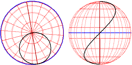
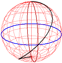
# The Earth and the route longitude = latitude ("y = x")
# I reduce the margins of the picture:
par( mai = c(0.2,0.2,0.2,0.2) )
# A partition of [0,2*pi]
t <- seq(0,2*pi,len=200)
z0 <- c(-1,1); u <- rep(z0[1],4)
z <- array(u,dim=c(2,2)); x <- c(-1,1); y <- c(-1,1)
# In x,y,z,z0 I defined the box. Now I choose the point of view and define the figure
trace <- function(x,y,z,z0,th,ph,di) {
F <- persp(x,y,z,theta=th,phi=ph,scale=TRUE,zlim=z0,xlim=x,ylim=y,d=di,border="white",box=FALSE)
# equator
lines(trans3d(cos(t),sin(t),0,pmat=F),col="blue",lwd=2)
# merdian of long. 0
lines(trans3d(cos(t),0,sin(t),pmat=F),col="brown",lwd=2)
# parallel
for (ang in seq(-90,90,len=10)*pi/180)
lines(trans3d(cos(ang)*cos(t),cos(ang)*sin(t),sin(ang),pmat=F),col="red",lty=3)
# merdians
for (ang in seq(0,170,len=10)*pi/180)
lines(trans3d(cos(ang)*cos(t),sin(ang)*cos(t),sin(t),pmat=F),col="red",lty=3)
# route longitude = latitude
ang <- seq(-90,90,len=200)*pi/180
lines(trans3d(cos(ang)*cos(ang),cos(ang)*sin(ang),sin(ang),pmat=F),col="black",lwd=2)
}
# I draw the figure from theta=80Ḟ,phi=20Ḟ,distance=1
trace(x,y,z,z0,80,20,1)
#
 # from another point of view
trace(x,y,z,z0,80,90,20)
# from another point of view
trace(x,y,z,z0,90,0,20)
# from another point of view
trace(x,y,z,z0,80,90,20)
# from another point of view
trace(x,y,z,z0,90,0,20)